Lattenbach
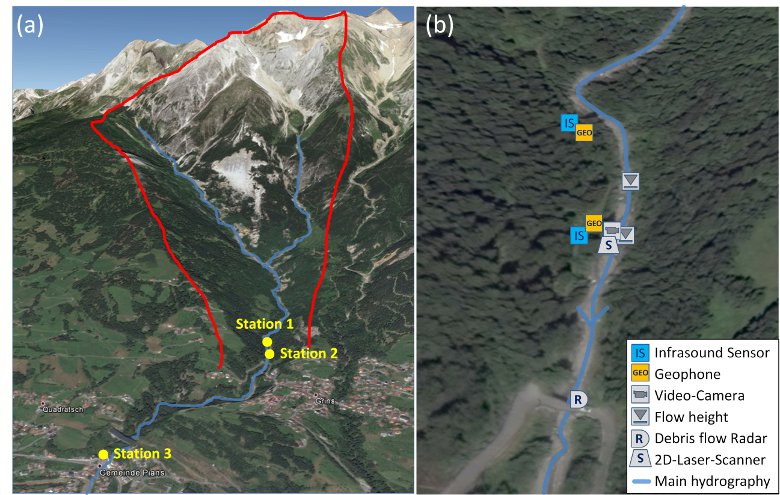
The Lattenbach torrent in Tyrol, with a catchment area of 5.3 km², is a monitoring site for debris flows operated by the Institute of Mountain Risk Engineering (BOKU, Vienna). It is a very active torrent located in a geologic fault zone, thus it has a large supply of loose sediment. The catchment ranges in elevation from the Dawinkopf at 2980 m a.s.l. down to the village Pians, where it flows into the Sanna at 830 m a.s.l.. Three monitoring stations are installed along the torrent which are equipped with radar gauges to measure the flow height, geophones, video cameras and meteorological monitoring stations. Two of this station are installed close together near the village Grins (at 1024 m a.s.l.) and a third monitoring station is installed down at the village Pians (Figure 1). At monitoring Station 2 also a 2D-Laser scanner in combination with a debris flow Puls-Doppler Radar (IBTP-Koschuch) for surface velocity can be used for an accurate estimation of the discharge and the total volume of debris flows with a time resolution of one second. Since 2013, the detection system consisting of a Chaparral infrasound sensor and a SM-4 geophone (changed in 2014 to a SG-5 geophone) is installed at the test site near the monitoring Station 2. In 2015, the infrasound sensor was changed to an Electret-microphone and a second system, also based on an Electret-microphone and a SG-5 geophone, has been installed around 90 m upstream at Station 1. The combination of this both systems can be used to determine the surge velocity of debris flows.

Fig. 1: (a) Overview of the test site Lattenbach (red line: catchment area); (b) Closer view of the monitoring Station 1 und 2 and sensor setup (Source: Google Maps).