Gadria
The Gadria-Strimm basins are located in the Vinschgau-Venosta valley, 30 km west of Meran-Merano in the North-eastern Italian Alps. The Gadria with a catchment area of 6.3 km², ranges in elevation from 2.945 m a.s.l down to 1.394 m a.s.l and features an average slope gradient of 79.1%. In the catchment an average of 1-2 events occur per year, with volumes ranging from 700 to 40,000 m³. The monitoring system consists of rain gauges, radar sensors, geophones, video cameras, piezometers and soil moisture probes. The monitoring started in 2011 in both channels, the Gadria and in the Strimm basin, but the focus lies within the Gadria where frequent debris flows occur. Debris flow depth is monitored by radar sensors at 3 cross-sections along the Gadria main channel and geophones have been installed at the same locations of the radar sensors in the Gadria channel since 2012. In order to provide visual information on debris flow characteristics, a series of video cameras with spotlights have been installed at the filter check dam and at other crucial locations. The detection system, consiting of an Electret-microphone and a SM-6 geophone, has been installed at the torrent in 2015 (Figure 1). In 2016 a special monitoring check dam has been built at the Gadria test site. This construction consists of 38 sensors, which measure the impact forces on the check dam, the acceleration of the construction and the interaction with the ground. Also the pore water pressures, weights and heights of the debris flows can be recorded. Here, the infrasound/seismic detection system is used to trigger these measurements in case of an event. In 2021 the system has been replaced by the new MAMODIS version and also a new station (S2) has been installed in the upper catchment.
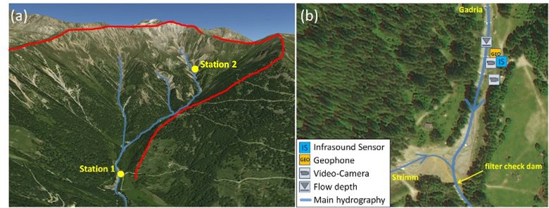
Fig. 1: (a) Overview of the test site Gadria (red line: catchment area); (b) Closer view of the monitoring Station 1 and sensor setup (Source: Google/Bing Maps).